Searching tsunami impacted area in the northern Sumatra (Tsunami generated by the 11 April 2012 M8.6 earthquake off the Sumatra island)
Laboratory of Remote Sensing and Geoinformatics for Disaster Management,
International Research Institute of Disaster Science, Tohoku University
Introduction
On 11 April, 2012, a M8.6 earthquake occurred off the west coast of northern Sumatra with strike-slip faulting. This eathquake generated tsunami to be observed in Indian Ocean. In the aftermath of the major earthquake tsunami, how fast we can detect the impact of natural disaster is a very critical problem to be solved for effective disaster relief activities. Recent advances of seismology, numerical modeling with modern computing power, remote sensing, and GIS analysis expands the capability to search and detect the impact of major tsunami disaster, as reported herein.
Resources
- Koshimura, S., M. Matsuoka, H. Gokon and Y. Namegaya, Searching tsunami affected area by integrating numerical modeling and remote sensing, Proc. International Geoscience and Remote Sensing Symposium, IEEE, CD-ROM, pp.3905-3908, 2010 (Published paper)
- Koshimura, S., M. Matsuoka and S. Kayaba, Integrated Approach to Assess the Impact of Tsunami Disaster, Proceedings of ICOSSAR 2009, pp.2302-2307, 2009 (Safety, Reliability and Risk of Structures, Infrastructures and Engineering Systems - Furuta, Frangopol & Shinozuka (eds.), 2010 Taylor & Francis Group, London) (Published paper)
- Dobson, J. E., E. A. Bright, P. R. Coleman, R.C. Durfee & B. A. Worley, LandScan: A Global Population Data-base for Estimating Populations at Risk," Photogrammetric Engineering & Remote Sensing Vol. 66, No. 7, 849-857, 2000.
Searching the impacted area
Tsunami modeling
Tsunami numerical modeling is performed by using TUNAMI-N2 code (non-linear shalllow water theory) with gebco 30 sec. bathymetry/topography grid.
- Geverning Equation : Non-linear Shallow Water Equations
- Numerical Scheme : Leap-frog Finite Difference Method (TUNAMI-CODE of Tohoku University)
- Spatial Grid Size : 30 arc-sec.
- Bathymetry Data : GEBCO
- Population Data : Landscan
Tsunami source model
Tsunami source model determined from USGS WPhase Moment Solution
- Case1
- Fault Length/Width : 380km/180km
- Dislocation : 4.2 m
- Fault mechanism : (Strike, Dip, Slip)=(107, 77, 155)

Model result
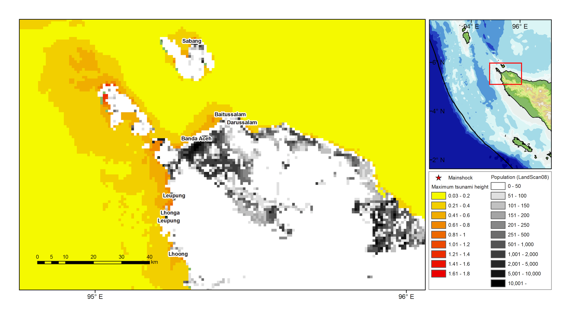
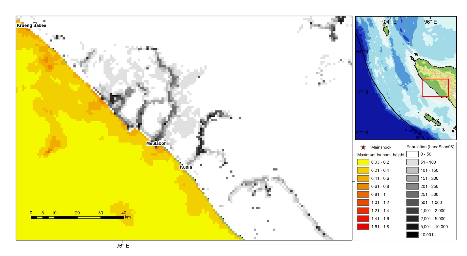
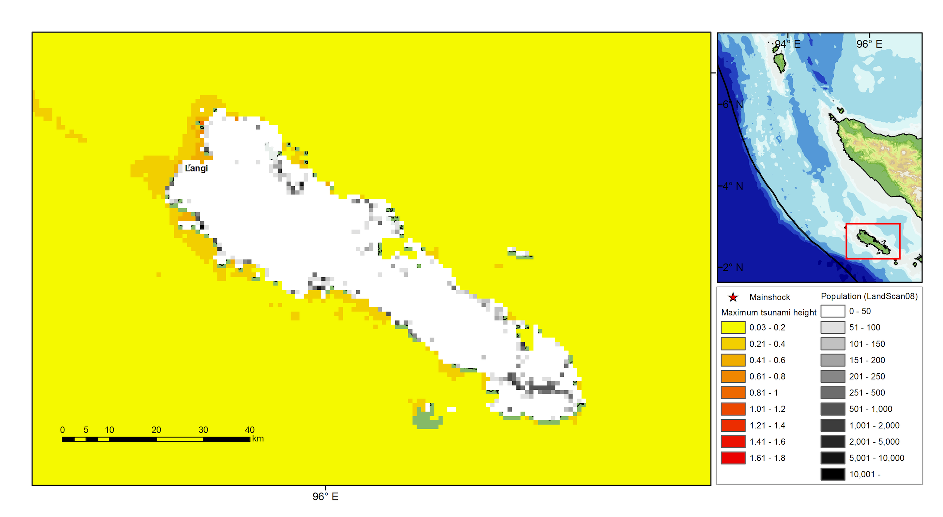
Maximum tsunami height

Tsunami simulation movie
Click to play(QuickTime)
- Case1
Modeled tsunami height and exposed population
The tsunami numerical model result is combined with world population database (Landscan) to explore the potential impacted area. The result suggests no significant impact along the Sumatra coast. Potentially 1m tsunami hit the coast as reported in Pacific Tsunami Warning Center. Looking at the population distribution along the Sumatra coast, some communities are highly exposed against the tsunami, but this time the tsunami was relatively small because of strike-slip faulting .

Contact (Lab. members)
- Shunichi Koshimura, Professor (koshimura@irides.tohoku.ac.jp)
- Hideomi Gokon, Ph.D. student
- Yusuke Suga and Satomi Hayashi, Graduate student
- Yuya Narita, Undergraduate student